


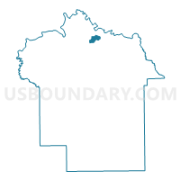
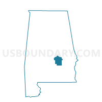
4O Wares Ferry Road Elementary School, Montgomery County, Alabama
About
Outline

Summary
| Unique Area Identifier | 522701 |
| Name | 4O Wares Ferry Road Elementary School |
| County | Montgomery County |
| State | Alabama |
| Area (square miles) | 2.24 |
| Land Area (square miles) | 2.18 |
| Water Area (square miles) | 0.06 |
| % of Land Area | 97.34 |
| % of Water Area | 2.66 |
| Latitude of the Internal Point | 32.40432240 |
| Longtitude of the Internal Point | -86.19096650 |
Maps

Graphs
Select a template below for downloading or customizing gragh for 4O Wares Ferry Road Elementary School, Montgomery County, Alabama


Neighbors
Neighoring Voting District (by Name) Neighboring Voting District on the Map
- 3D Lagoon Park Fire Station Voting District, Montgomery County, AL
- 3F Goodwyn Community Center Voting District, Montgomery County, AL
- 3I Eastdale Baptist Church Voting District, Montgomery County, AL
- 4J Union Chapel AME Zion Church Voting District, Montgomery County, AL
- 5K Lakeview Baptist Church Voting Center, Montgomery County, AL
Top 10 Neighboring County Subdivision (by Population) Neighboring County Subdivision on the Map
Top 10 Neighboring Place (by Population) Neighboring Place on the Map
Top 10 Neighboring Unified School District (by Population) Neighboring Unified School District on the Map
Top 10 Neighboring State Legislative District Lower Chamber (by Population) Neighboring State Legislative District Lower Chamber on the Map
- State House District 75, AL (60,140)
- State House District 74, AL (41,047)
- State House District 77, AL (34,998)
Top 10 Neighboring State Legislative District Upper Chamber (by Population) Neighboring State Legislative District Upper Chamber on the Map
Top 10 Neighboring 111th Congressional District (by Population) Neighboring 111th Congressional District on the Map
Top 10 Neighboring Census Tract (by Population) Neighboring Census Tract on the Map
- Census Tract 54.08, Montgomery County, AL (7,637)
- Census Tract 54.02, Montgomery County, AL (5,656)
- Census Tract 51.01, Montgomery County, AL (3,689)
- Census Tract 53.02, Montgomery County, AL (2,104)